
c-map
Original price
$129.00
-
Original price
$129.00
Original price
$129.00
$129.00
-
$129.00
Current price
$129.00
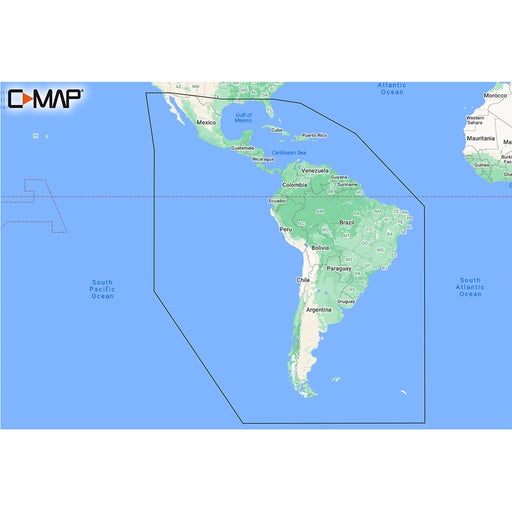
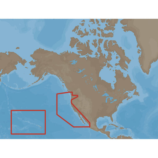
C-MAP M-SA-Y038-MS Discover South America Caribbean [M-SA-Y038-MS]
C-MAP
Out of stock
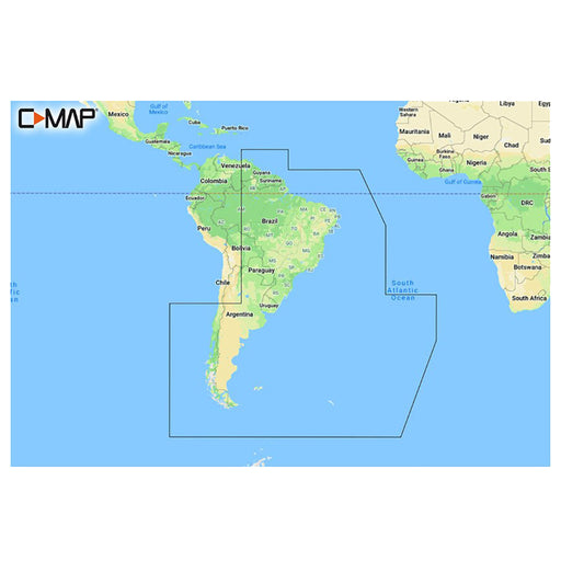
M-SA-Y038-MS DISCOVER™ South America and Caribbean Whether cruising, fishing or sailing, C-MAP DISCOVER™ offers ultra-wide coverage and includes a...
View full details
Original price
$129.00
-
Original price
$129.00
Original price
$129.00
$129.00
-
$129.00
Current price
$129.00
Sold out
Original price
$291.00
-
Original price
$291.00
Original price
$291.00
$291.00
-
$291.00
Current price
$291.00
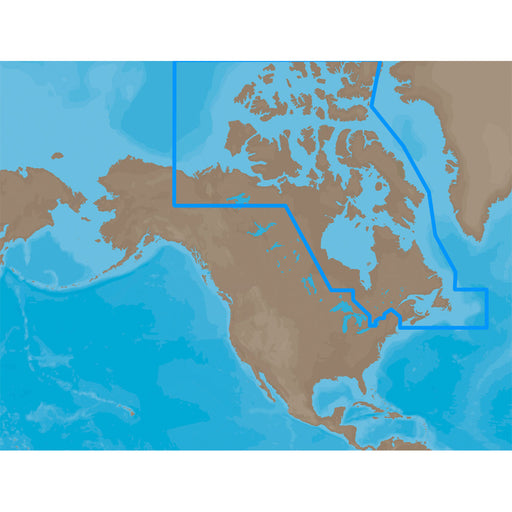
C-MAP MAX NA-M021 - Canada North & East - SD Card [NA-M021SDCARD]
C-MAP
Only 5 left!
NA-M021 => Canada North and EastCoverage of the Arctic and Atlantic coasts of Canada including Hudson Bay, Newfoundland, the Gulf of St. Lawren...
View full details
Original price
$291.00
-
Original price
$291.00
Original price
$291.00
$291.00
-
$291.00
Current price
$291.00
Original price
$291.00
-
Original price
$291.00
Original price
$291.00
$291.00
-
$291.00
Current price
$291.00
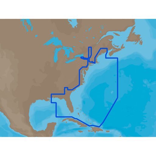
C-MAP MAX NA-M022 - U.S. East Coast & The Bahamas - SD Card [M-NA-M022-MS]
C-MAP
Only 5 left!
NA-M022 => USA East Coast and BahamasCoverage of the United States Atlantic coast from Passamaquoddy Bay, ME down to Key West, FL, with extende...
View full details
Original price
$291.00
-
Original price
$291.00
Original price
$291.00
$291.00
-
$291.00
Current price
$291.00
Original price
$291.00
-
Original price
$291.00
Original price
$291.00
$291.00
-
$291.00
Current price
$291.00
C-MAP MAX NA-M023 - U.S. Gulf Coast & Inland Rivers - SD Card [NA-M023SDCARD]
C-MAP
Only 5 left!
NA-M023 => Gulf of Mexico, Great Lakes and RiversCoverage of the Gulf states, starting from Boca Raton, FL, down to Key West, FL, then back up ...
View full details
Original price
$291.00
-
Original price
$291.00
Original price
$291.00
$291.00
-
$291.00
Current price
$291.00
Original price
$291.00
-
Original price
$291.00
Original price
$291.00
$291.00
-
$291.00
Current price
$291.00
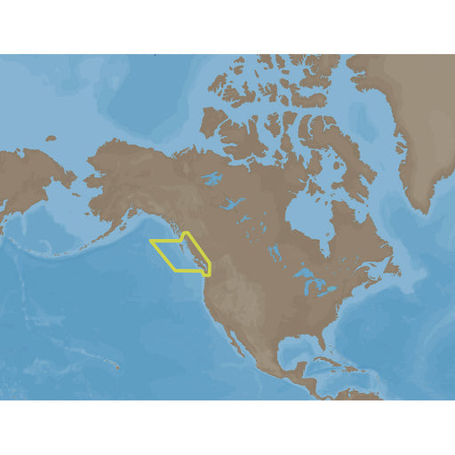
C-MAP MAX NA-M024 - U.S. West Coast & Hawaii - SD Card [NA-M024SDCARD]
C-MAP
Only 5 left!
NA-M024 => USA West Coast and HawaiiCoverage of the Pacific Coast of the United States, including all of the coasts of California, Oregon and W...
View full details
Original price
$291.00
-
Original price
$291.00
Original price
$291.00
$291.00
-
$291.00
Current price
$291.00
Original price
$291.00
-
Original price
$291.00
Original price
$291.00
$291.00
-
$291.00
Current price
$291.00
C-MAP MAX NA-M025 - Canada West - SD Card [NA-M025SDCARD]
C-MAP
Only 5 left!
NA-M025 => Canada WestCoverage of British Columbia, Puget Sound and the San Juan Islands. Full coverage of Vancouver Island and the Queen Char...
View full details
Original price
$291.00
-
Original price
$291.00
Original price
$291.00
$291.00
-
$291.00
Current price
$291.00
Original price
$291.00
-
Original price
$291.00
Original price
$291.00
$291.00
-
$291.00
Current price
$291.00
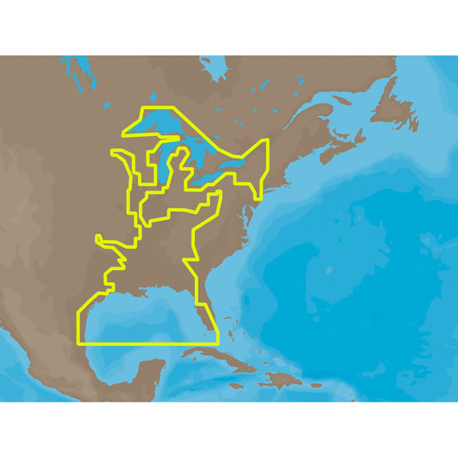
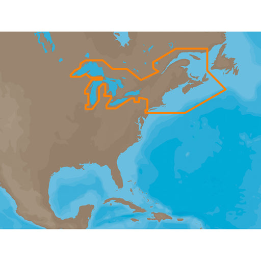
C-MAP MAX NA-M026 - Great Lakes & The Maritimes - SD Card [NA-M026SDCARD]
C-MAP
Only 5 left!
NA-M026 => Great Lakes, Northeast Coast and ApproachesCoverage of the Great Lakes, St. Lawrence River and Northeast United States. Coverage of...
View full details
Original price
$291.00
-
Original price
$291.00
Original price
$291.00
$291.00
-
$291.00
Current price
$291.00
Original price
$291.00
-
Original price
$291.00
Original price
$291.00
$291.00
-
$291.00
Current price
$291.00
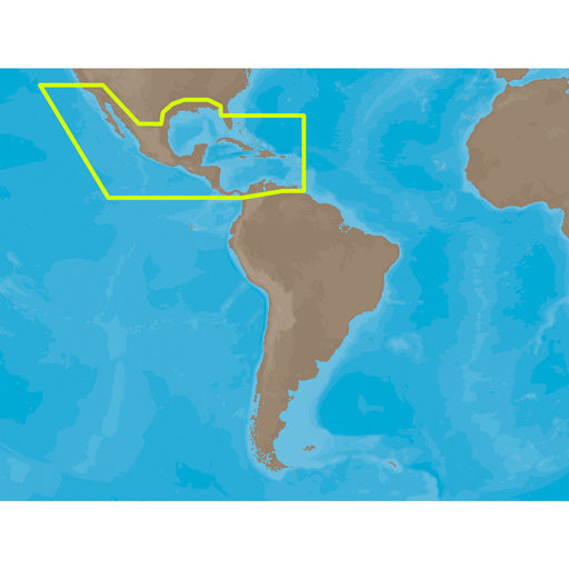
C-MAP MAX NA-M027 - Central America & The Caribbean - SD Card [NA-M027SDCARD]
C-MAP
Only 5 left!
NA-M027 => Central America and CaribbeanCoverage of Central America, all of the Caribbean and the northern coast of South America, and the Gulf...
View full details
Original price
$291.00
-
Original price
$291.00
Original price
$291.00
$291.00
-
$291.00
Current price
$291.00
Original price
$291.00
-
Original price
$291.00
Original price
$291.00
$291.00
-
$291.00
Current price
$291.00
C-MAP MAX NA-M028 - Alaska - SD Card [NA-M028SDCARD]
C-MAP
Only 5 left!
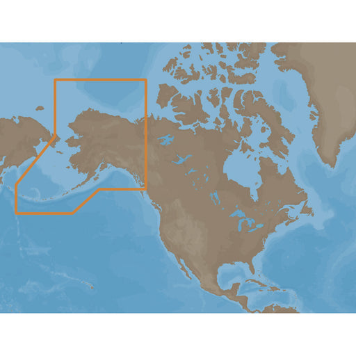
NA-M028 => AlaskaCoverage of the southern Alaska coast from Dixon Entrance up and over to Kodiak Island. Includes all of the Aleutian Islands ...
View full details
Original price
$291.00
-
Original price
$291.00
Original price
$291.00
$291.00
-
$291.00
Current price
$291.00
Original price
$291.00
-
Original price
$291.00
Original price
$291.00
$291.00
-
$291.00
Current price
$291.00
C-MAP MAX SA-M500 - Costa Rica-Chile Falklands - SD Card [SA-M500SDCARD]
C-MAP
Only 5 left!
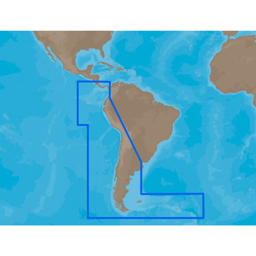
SA-M500 => Costa Rica to Chile to FalklandsCoverage starts at Bahia de Salinas on Costa Rica's Pacific coast, and extends south and east along ...
View full details
Original price
$291.00
-
Original price
$291.00
Original price
$291.00
$291.00
-
$291.00
Current price
$291.00
Original price
$291.00
-
Original price
$291.00
Original price
$291.00
$291.00
-
$291.00
Current price
$291.00
C-MAP MAX SA-M501 - Gulf of Paria - Cape Horn - SD Card [SA-M501SDCARD]
C-MAP
Only 5 left!
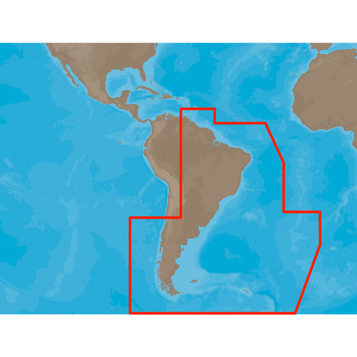
SA-M501 => Gulf of Paria to Cape HornCoverage starts at Quintero, Chile on the Pacific coast and extends south down the Chile border, wraps up ...
View full details
Original price
$291.00
-
Original price
$291.00
Original price
$291.00
$291.00
-
$291.00
Current price
$291.00
Original price
$260.00
-
Original price
$260.00
Original price
$260.00
$260.00
-
$260.00
Current price
$260.00
C-MAP REVEAL Chart - South America - East Coast [M-SA-Y501-MS]
C-MAP
Out of stock
REVEAL™ Chart - South America - East CoastThe premium mapping solution for cruisers, anglers, and sailors looking for accurate, quality data with ...
View full details
Original price
$260.00
-
Original price
$260.00
Original price
$260.00
$260.00
-
$260.00
Current price
$260.00
Sold out
Original price
$0.00
-
Original price
$0.00
Original price
$0.00
$260.00
$260.00
-
$260.00
Current price
$260.00
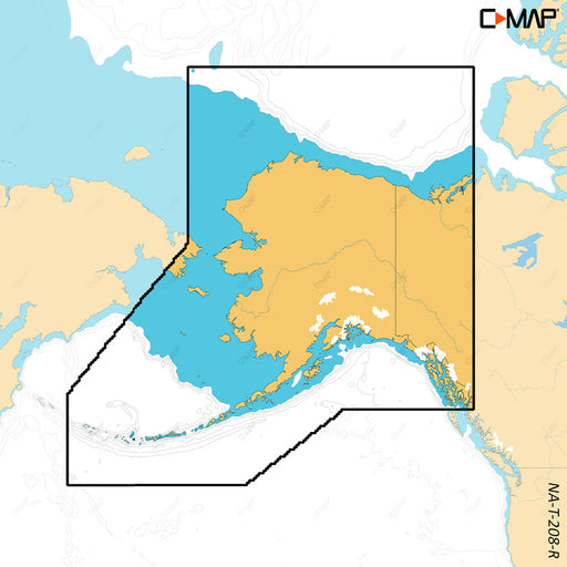
C-MAP REVEAL X - Alaska [M-NA-T-208-R-MS]
C-MAP
Out of stock
REVEAL™ X - AlaskaCOMPATIBILITY WITH SIMRAD NSX SERIES ONLYExperience the X Generation of C-MAP charts - with game-changing Shaded Relief!C-MAP® R...
View full details
Original price
$0.00
-
Original price
$0.00
Original price
$0.00
$260.00
$260.00
-
$260.00
Current price
$260.00
Sold out
Original price
$0.00
-
Original price
$0.00
Original price
$0.00
$260.00
$260.00
-
$260.00
Current price
$260.00
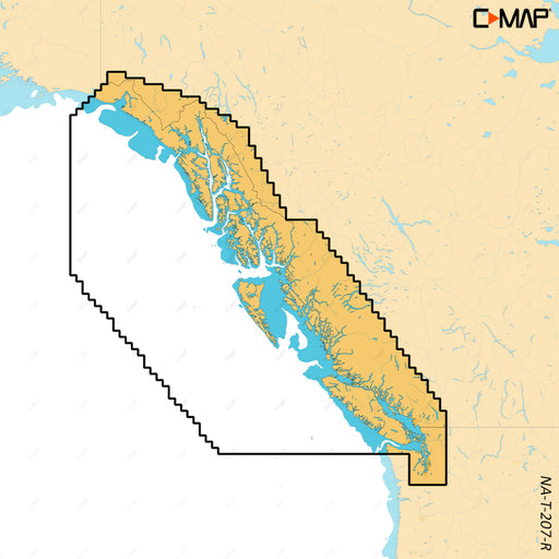
C-MAP REVEAL X - British Columbia Puget Sound [M-NA-T-207-R-MS]
C-MAP
Out of stock
REVEAL™ X - British Columbia & Puget SoundCOMPATIBILITY WITH SIMRAD NSX SERIES ONLYExperience the X Generation of C-MAP charts - with game-cha...
View full details
Original price
$0.00
-
Original price
$0.00
Original price
$0.00
$260.00
$260.00
-
$260.00
Current price
$260.00
Sold out
Original price
$177.00
-
Original price
$177.00
Original price
$177.00
$177.00
-
$177.00
Current price
$177.00
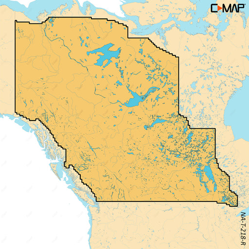
C-MAP REVEAL X - Canada Lake Insight West HD [M-NA-T-218-R-MS]
C-MAP
Out of stock
REVEAL™ X - Canada Lake Insight West HDCOMPATIBILITY WITH SIMRAD NSX SERIES ONLYExperience the X Generation of C-MAP charts - with game-changing S...
View full details
Original price
$177.00
-
Original price
$177.00
Original price
$177.00
$177.00
-
$177.00
Current price
$177.00
Sold out
Original price
$177.00
-
Original price
$177.00
Original price
$177.00
$177.00
-
$177.00
Current price
$177.00
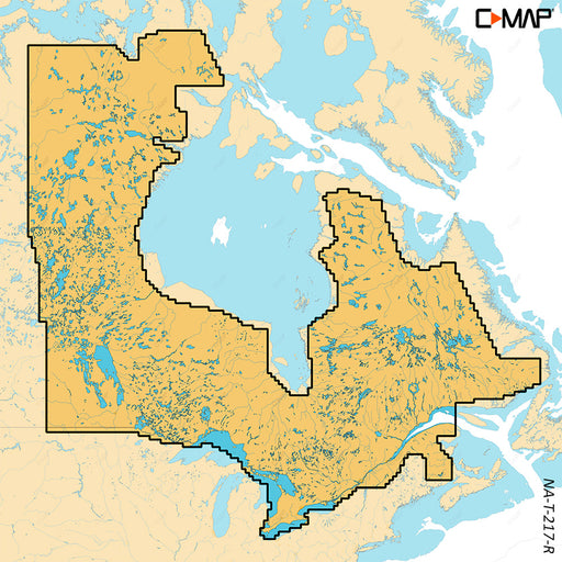
C-MAP REVEAL X - Canada Lakes Insight East HD [M-NA-T-217-R-MS]
C-MAP
Out of stock
REVEAL™ X - Canada Lakes Insight East HDCOMPATIBILITY WITH SIMRAD NSX SERIES ONLYExperience the X Generation of C-MAP charts - with game-changing ...
View full details
Original price
$177.00
-
Original price
$177.00
Original price
$177.00
$177.00
-
$177.00
Current price
$177.00
Sold out
Original price
$0.00
-
Original price
$0.00
Original price
$0.00
$260.00
$260.00
-
$260.00
Current price
$260.00
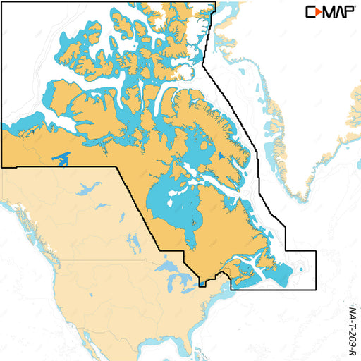
C-MAP REVEAL X - Canada North East [M-NA-T-209-R-MS]
C-MAP
Out of stock
REVEAL™ X - Canada North & EastCOMPATIBILITY WITH SIMRAD NSX SERIES ONLYExperience the X Generation of C-MAP charts - with game-changing Shade...
View full details
Original price
$0.00
-
Original price
$0.00
Original price
$0.00
$260.00
$260.00
-
$260.00
Current price
$260.00
Sold out
Original price
$0.00
-
Original price
$0.00
Original price
$0.00
$260.00
$260.00
-
$260.00
Current price
$260.00
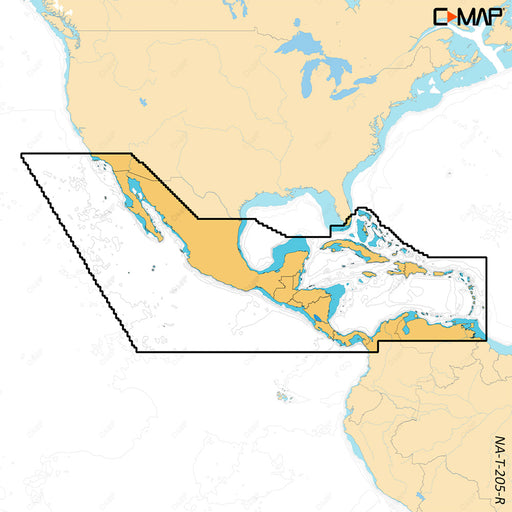
C-MAP REVEAL X - Central America Caribbean [M-NA-T-205-R-MS]
C-MAP
Out of stock
REVEAL™ X - Central America & CaribbeanCOMPATIBILITY WITH SIMRAD NSX SERIES ONLYExperience the X Generation of C-MAP charts - with game-changi...
View full details
Original price
$0.00
-
Original price
$0.00
Original price
$0.00
$260.00
$260.00
-
$260.00
Current price
$260.00
Sold out
Original price
$0.00
-
Original price
$0.00
Original price
$0.00
$260.00
$260.00
-
$260.00
Current price
$260.00
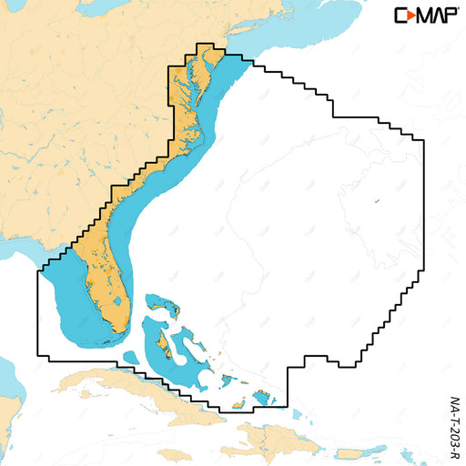
C-MAP REVEAL X - Chesapeake Bay to the Bahamas [M-NA-T-203-R-MS]
C-MAP
Only 1 left!
REVEAL™ X - Chesapeake Bay to the BahamasCOMPATIBILITY WITH SIMRAD NSX SERIES ONLYExperience the X Generation of C-MAP charts - with game-changing...
View full details
Original price
$0.00
-
Original price
$0.00
Original price
$0.00
$260.00
$260.00
-
$260.00
Current price
$260.00
Original price
$260.00
-
Original price
$260.00
Original price
$260.00
$260.00
-
$260.00
Current price
$260.00
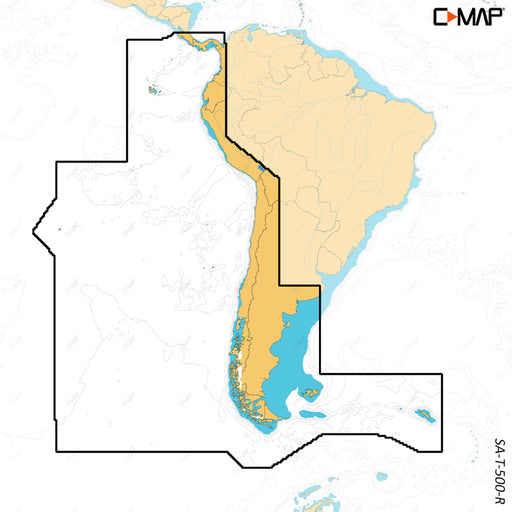
C-MAP REVEAL X - Costa Rica Chile Falklands [M-SA-T-500-R-MS]
C-MAP
Out of stock
REVEAL™ X - Costa Rica Chile & FalklandsCOMPATIBILITY WITH SIMRAD NSX SERIES ONLYExperience the X Generation of C-MAP charts - with game-chang...
View full details
Original price
$260.00
-
Original price
$260.00
Original price
$260.00
$260.00
-
$260.00
Current price
$260.00
Sold out
Original price
$0.00
-
Original price
$0.00
Original price
$0.00
$260.00
$260.00
-
$260.00
Current price
$260.00
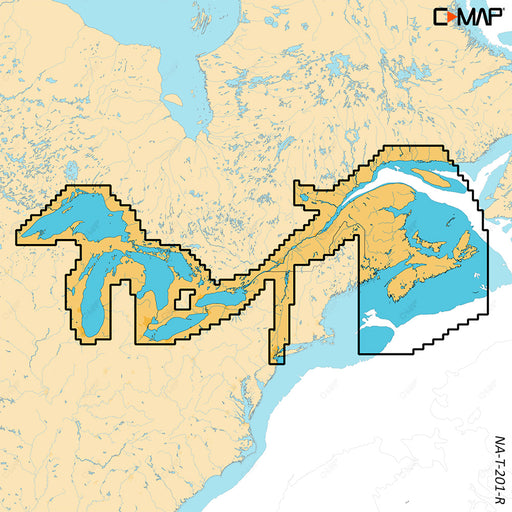
C-MAP REVEAL X - Great Lakes to Nova Scotia [M-NA-T-201-R-MS]
C-MAP
Out of stock
REVEAL™ X - Great Lakes to Nova ScotiaCOMPATIBILITY WITH SIMRAD NSX SERIES ONLYExperience the X Generation of C-MAP charts - with game-changing Sh...
View full details
Original price
$0.00
-
Original price
$0.00
Original price
$0.00
$260.00
$260.00
-
$260.00
Current price
$260.00
Sold out
Original price
$0.00
-
Original price
$0.00
Original price
$0.00
$260.00
$260.00
-
$260.00
Current price
$260.00
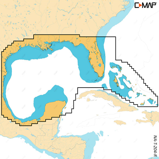
C-MAP REVEAL X - Gulf of Mexico Bahamas [M-NA-T-204-R-MS]
C-MAP
Out of stock
REVEAL™ X - Gulf of Mexico & BahamasCOMPATIBILITY WITH SIMRAD NSX SERIES ONLYExperience the X Generation of C-MAP charts - with game-changing ...
View full details
Original price
$0.00
-
Original price
$0.00
Original price
$0.00
$260.00
$260.00
-
$260.00
Current price
$260.00
Sold out
Original price
$260.00
-
Original price
$260.00
Original price
$260.00
$260.00
-
$260.00
Current price
$260.00
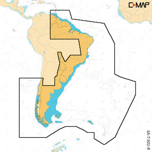
C-MAP REVEAL X - Gulf of Paria to Cape Horn [M-SA-T-501-R-MS]
C-MAP
Out of stock
REVEAL™ X - Gulf of Paria to Cape HornCOMPATIBILITY WITH SIMRAD NSX SERIES ONLYExperience the X Generation of C-MAP charts - with game-changing Sh...
View full details
Original price
$260.00
-
Original price
$260.00
Original price
$260.00
$260.00
-
$260.00
Current price
$260.00
Sold out
Original price
$0.00
-
Original price
$0.00
Original price
$0.00
$260.00
$260.00
-
$260.00
Current price
$260.00
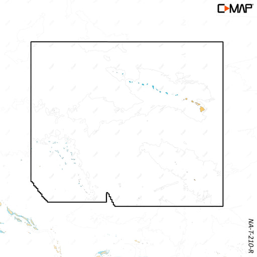
C-MAP REVEAL X - Hawaii Marshall Islands French Polynesia [M-NA-T-210-R-MS]
C-MAP
Out of stock
REVEAL™ X - Hawaii Marshall Islands French PolynesiaCOMPATIBILITY WITH SIMRAD NSX SERIES ONLYExperience the X Generation of C-MAP charts - with ga...
View full details
Original price
$0.00
-
Original price
$0.00
Original price
$0.00
$260.00
$260.00
-
$260.00
Current price
$260.00
Sold out