C-MAP
Original price
$207.00
-
Original price
$207.00
Original price
$207.00
$207.00
-
$207.00
Current price
$207.00
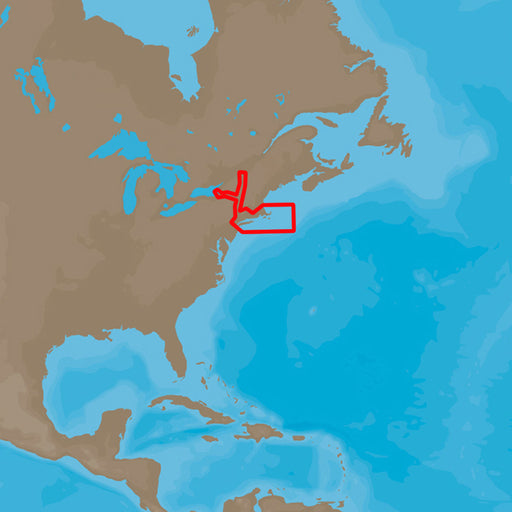
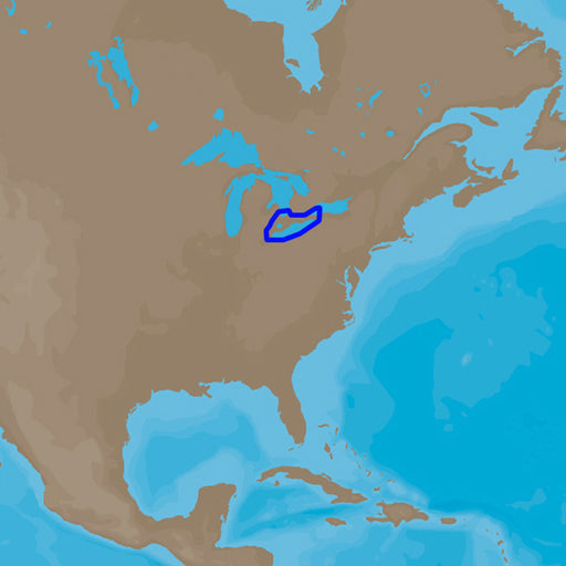
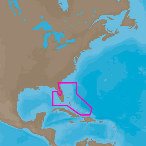
C-MAP 4D NA-940 Cape Cod, Long Island & Hudson River [M-NA-D940-MS]
C-MAP
Out of stock
C-MAP 4D NA-D940 Cape Cod, Long Island & Hudson RiverThe next evolution in navigation solutions. C-MAP 4D adapts to your boating needs becaus...
View full details
Original price
$207.00
-
Original price
$207.00
Original price
$207.00
$207.00
-
$207.00
Current price
$207.00
Sold out
Original price
$207.00
-
Original price
$207.00
Original price
$207.00
$207.00
-
$207.00
Current price
$207.00
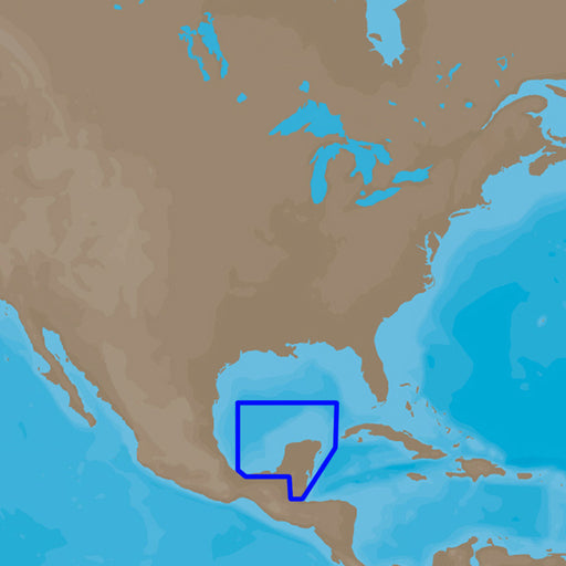
C-MAP 4D NA-947 Coatzacoalcos, MX to Honduras Bay, GT [M-NA-D947-MS]
C-MAP
Out of stock
C-MAP 4D NA-D947 Coatzacoalcos, MX to Honduras Bay, GTThe next evolution in navigation solutions. C-MAP 4D adapts to your boating needs because i...
View full details
Original price
$207.00
-
Original price
$207.00
Original price
$207.00
$207.00
-
$207.00
Current price
$207.00
Sold out
Original price
$207.00
-
Original price
$207.00
Original price
$207.00
$207.00
-
$207.00
Current price
$207.00
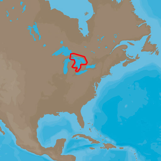
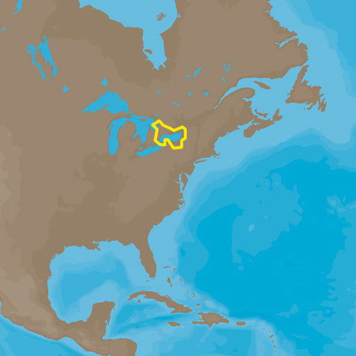
C-MAP 4D NA-D932 Lake Huron and Georgian Bay [M-NA-D932-MS]
C-MAP
Out of stock
C-MAP 4D NA-D932 Lake Huron and Georgian BayThe next evolution in navigation solutions. C-MAP 4D adapts to your boating needs because it's the onl...
View full details
Original price
$207.00
-
Original price
$207.00
Original price
$207.00
$207.00
-
$207.00
Current price
$207.00
Sold out
Original price
$207.00
-
Original price
$207.00
Original price
$207.00
$207.00
-
$207.00
Current price
$207.00
C-MAP 4D NA-D933 Lake Erie and Lake St Clair [M-NA-D933-MS]
C-MAP
Out of stock
C-MAP 4D NA-D933 Lake Erie and Lake St ClaireThe next evolution in navigation solutions. C-MAP 4D adapts to your boating needs because it's the on...
View full details
Original price
$207.00
-
Original price
$207.00
Original price
$207.00
$207.00
-
$207.00
Current price
$207.00
Sold out
Original price
$207.00
-
Original price
$207.00
Original price
$207.00
$207.00
-
$207.00
Current price
$207.00
C-MAP 4D NA-D934 Lake Ontario and Trent Severn [M-NA-D934-MS]
C-MAP
Out of stock
C-MAP 4D NA-D934 Lake Ontario and Trent SevernThe next evolution in navigation solutions. C-MAP 4D adapts to your boating needs because it's the o...
View full details
Original price
$207.00
-
Original price
$207.00
Original price
$207.00
$207.00
-
$207.00
Current price
$207.00
Sold out
Original price
$207.00
-
Original price
$207.00
Original price
$207.00
$207.00
-
$207.00
Current price
$207.00
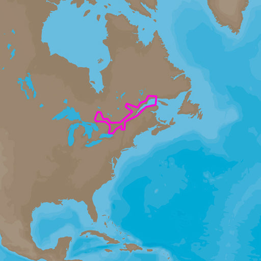
C-MAP 4D NA-D935 St Lawrence River [M-NA-D935-MS]
C-MAP
Out of stock
C-MAP 4D NA-D935 St Lawrence RiverThe next evolution in navigation solutions. C-MAP 4D adapts to your boating needs because it's the only digital...
View full details
Original price
$207.00
-
Original price
$207.00
Original price
$207.00
$207.00
-
$207.00
Current price
$207.00
Sold out
Original price
$207.00
-
Original price
$207.00
Original price
$207.00
$207.00
-
$207.00
Current price
$207.00
C-MAP 4D NA-D936 Gulf of St. Lawrence [M-NA-D936-MS]
C-MAP
Out of stock
C-MAP 4D NA-D93 Gulf of St.LawrenceThe next evolution in navigation solutions. C-MAP 4D adapts to your boating needs because it's the only digita...
View full details
Original price
$207.00
-
Original price
$207.00
Original price
$207.00
$207.00
-
$207.00
Current price
$207.00
Sold out
Original price
$207.00
-
Original price
$207.00
Original price
$207.00
$207.00
-
$207.00
Current price
$207.00
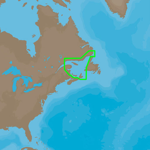
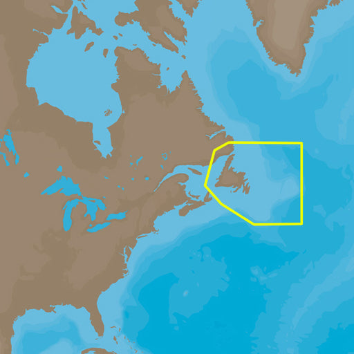
C-MAP 4D NA-D937 Newfoundland [M-NA-D937-MS]
C-MAP
Out of stock
C-MAP 4D NA-D937 NewfoundlandThe next evolution in navigation solutions. C-MAP 4D adapts to your boating needs because it's the only digital char...
View full details
Original price
$207.00
-
Original price
$207.00
Original price
$207.00
$207.00
-
$207.00
Current price
$207.00
Sold out
Original price
$207.00
-
Original price
$207.00
Original price
$207.00
$207.00
-
$207.00
Current price
$207.00
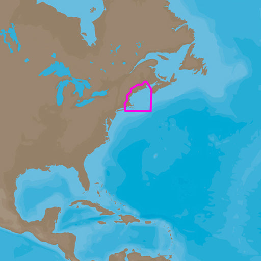
C-MAP 4D NA-D939 Passamaquoddy Bay to Block Island [M-NA-D939-MS]
C-MAP
Out of stock
C-MAP 4D NA-D939 Passamaquoddy Bay to Block IslandThe next evolution in navigation solutions. C-MAP 4D adapts to your boating needs because it's ...
View full details
Original price
$207.00
-
Original price
$207.00
Original price
$207.00
$207.00
-
$207.00
Current price
$207.00
Sold out
Original price
$207.00
-
Original price
$207.00
Original price
$207.00
$207.00
-
$207.00
Current price
$207.00
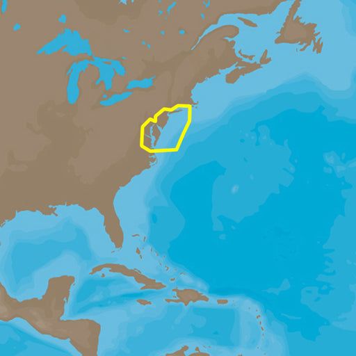
C-MAP 4D NA-D941 Block Island to Norfolk [M-NA-D941-MS]
C-MAP
Out of stock
C-MAP 4D NA-D941 Block Island to NorfolkThe next evolution in navigation solutions. C-MAP 4D adapts to your boating needs because it's the only d...
View full details
Original price
$207.00
-
Original price
$207.00
Original price
$207.00
$207.00
-
$207.00
Current price
$207.00
Sold out
Original price
$207.00
-
Original price
$207.00
Original price
$207.00
$207.00
-
$207.00
Current price
$207.00
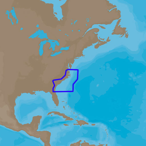
C-MAP 4D NA-D942 Norfolk to Jacksonville [M-NA-D942-MS]
C-MAP
Out of stock
C-MAP 4D NA-D942 Norfolk to JacksonvilleThe next evolution in navigation solutions. C-MAP 4D adapts to your boating needs because it's the only d...
View full details
Original price
$207.00
-
Original price
$207.00
Original price
$207.00
$207.00
-
$207.00
Current price
$207.00
Sold out
Original price
$207.00
-
Original price
$207.00
Original price
$207.00
$207.00
-
$207.00
Current price
$207.00
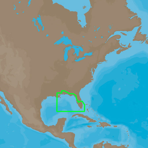
C-MAP 4D NA-D943 Florida & The Bahamas [M-NA-D943-MS]
C-MAP
Out of stock
C-MAP 4D NA-D943 Florida & The BahamasThe next evolution in navigation solutions. C-MAP 4D adapts to your boating needs because it's the only...
View full details
Original price
$207.00
-
Original price
$207.00
Original price
$207.00
$207.00
-
$207.00
Current price
$207.00
Sold out
Original price
$207.00
-
Original price
$207.00
Original price
$207.00
$207.00
-
$207.00
Current price
$207.00
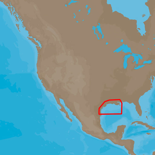
C-MAP 4D NA-D944 St. Lucie Inlet to New Orleans [M-NA-D944-MS]
C-MAP
Out of stock
C-MAP 4D NA-D944 St. Lucie Inlet to New OrleansThe next evolution in navigation solutions. C-MAP 4D adapts to your boating needs because it's the...
View full details
Original price
$207.00
-
Original price
$207.00
Original price
$207.00
$207.00
-
$207.00
Current price
$207.00
Sold out
Original price
$207.00
-
Original price
$207.00
Original price
$207.00
$207.00
-
$207.00
Current price
$207.00
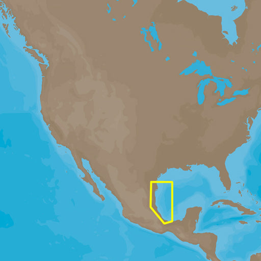
C-MAP 4D NA-D945 New Orleans to Brownsville [M-NA-D945-MS]
C-MAP
Out of stock
C-MAP 4D NA-D945 New Orleans to BrownsvilleThe next evolution in navigation solutions. C-MAP 4D adapts to your boating needs because it's the onl...
View full details
Original price
$207.00
-
Original price
$207.00
Original price
$207.00
$207.00
-
$207.00
Current price
$207.00
Sold out
Original price
$207.00
-
Original price
$207.00
Original price
$207.00
$207.00
-
$207.00
Current price
$207.00
C-MAP 4D NA-D946 Brownsville, TX to Coatzacoalcos, MX [M-NA-D946-MS]
C-MAP
Out of stock
C-MAP 4D NA-D946 Brownsville, TX to Coatzacaolcos, MXThe next evolution in navigation solutions. C-MAP 4D adapts to your boating needs because it...
View full details
Original price
$207.00
-
Original price
$207.00
Original price
$207.00
$207.00
-
$207.00
Current price
$207.00
Sold out
Original price
$207.00
-
Original price
$207.00
Original price
$207.00
$207.00
-
$207.00
Current price
$207.00
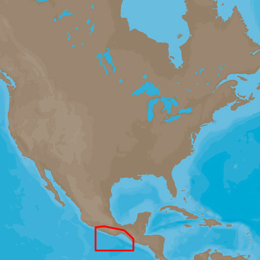
C-MAP 4D NA-D948 Champerico, GT to Acapulco, MX [M-NA-D948-MS]
C-MAP
Out of stock
C-MAP 4D NA-D948 Champerico, GT to Acapulco, MXThe next evolution in navigation solutions. C-MAP 4D adapts to your boating needs because it's the...
View full details
Original price
$207.00
-
Original price
$207.00
Original price
$207.00
$207.00
-
$207.00
Current price
$207.00
Sold out
Original price
$207.00
-
Original price
$207.00
Original price
$207.00
$207.00
-
$207.00
Current price
$207.00
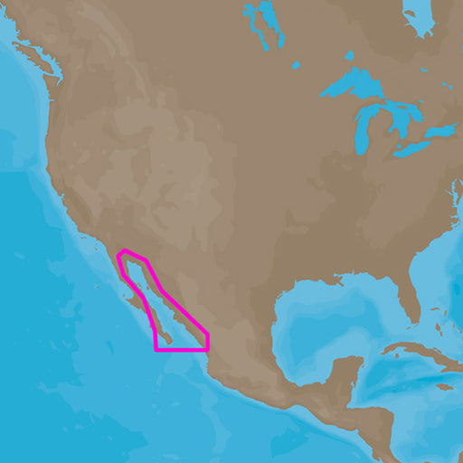
C-MAP 4D NA-D949 Acapulco, MX to Mazatlan, MX [M-NA-D949-MS]
C-MAP
Out of stock
C-MAP 4D NA-D949 Acapulco, MX to Mazatlan, MXThe next evolution in navigation solutions. C-MAP 4D adapts to your boating needs because it's the o...
View full details
Original price
$207.00
-
Original price
$207.00
Original price
$207.00
$207.00
-
$207.00
Current price
$207.00
Sold out
Original price
$207.00
-
Original price
$207.00
Original price
$207.00
$207.00
-
$207.00
Current price
$207.00
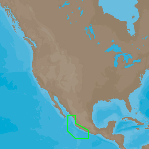
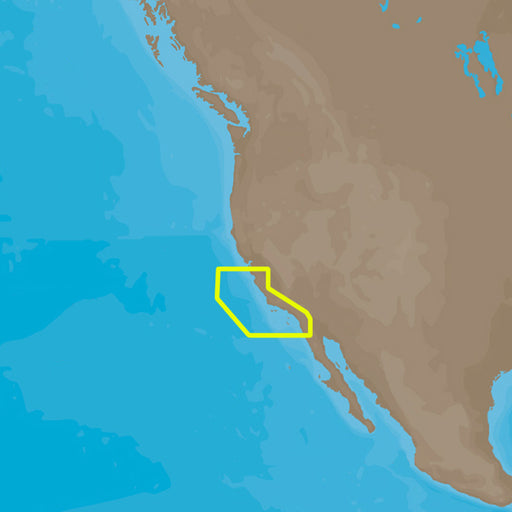
C-MAP 4D NA-D950 Gulf of Califonia , Mexico [M-NA-D950-MS]
C-MAP
Out of stock
C-MAP 4D NA-D950 Gulf of California, MexicoThe next evolution in navigation solutions. C-MAP 4D adapts to your boating needs because it's the onl...
View full details
Original price
$207.00
-
Original price
$207.00
Original price
$207.00
$207.00
-
$207.00
Current price
$207.00
Sold out
Original price
$207.00
-
Original price
$207.00
Original price
$207.00
$207.00
-
$207.00
Current price
$207.00
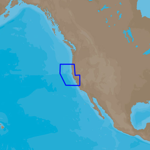
C-MAP 4D NA-D952 San Diego to Santa Cruz [M-NA-D952-MS]
C-MAP
Out of stock
C-MAP 4D NA-D952 San Diego to Santa CruzThe next evolution in navigation solutions. C-MAP 4D adapts to your boating needs because it's the only d...
View full details
Original price
$207.00
-
Original price
$207.00
Original price
$207.00
$207.00
-
$207.00
Current price
$207.00
Sold out
Original price
$207.00
-
Original price
$207.00
Original price
$207.00
$207.00
-
$207.00
Current price
$207.00
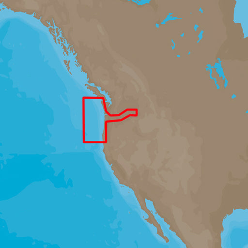
C-MAP 4D NA-D953 Point Sur to Cape Blanco [M-NA-D953-MS]
C-MAP
Out of stock
C-MAP 4D NA-D953 Point Sur to Cape BlancoThe next evolution in navigation solutions. C-MAP 4D adapts to your boating needs because it's the only ...
View full details
Original price
$207.00
-
Original price
$207.00
Original price
$207.00
$207.00
-
$207.00
Current price
$207.00
Sold out
Original price
$207.00
-
Original price
$207.00
Original price
$207.00
$207.00
-
$207.00
Current price
$207.00
C-MAP 4D NA-D954 Cape Blanco to Cape Flattery [M-NA-D954-MS]
C-MAP
Out of stock
C-MAP 4D NA-D954 Cape Blanco to Cape FlatteryThe next evolution in navigation solutions. C-MAP 4D adapts to your boating needs because it's the o...
View full details
Original price
$207.00
-
Original price
$207.00
Original price
$207.00
$207.00
-
$207.00
Current price
$207.00
Sold out
Original price
$207.00
-
Original price
$207.00
Original price
$207.00
$207.00
-
$207.00
Current price
$207.00
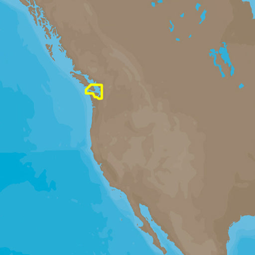
C-MAP 4D NA-D955 Puget Sound, Juan De Fuca & San Juan Island [M-NA-D955-MS]
C-MAP
Out of stock
C-MAP 4D NA-D955 Puget Sound, Juan De Fuca & San Juan IslandThe next evolution in navigation solutions. C-MAP 4D adapts to your boating needs...
View full details
Original price
$207.00
-
Original price
$207.00
Original price
$207.00
$207.00
-
$207.00
Current price
$207.00
Sold out
Original price
$207.00
-
Original price
$207.00
Original price
$207.00
$207.00
-
$207.00
Current price
$207.00
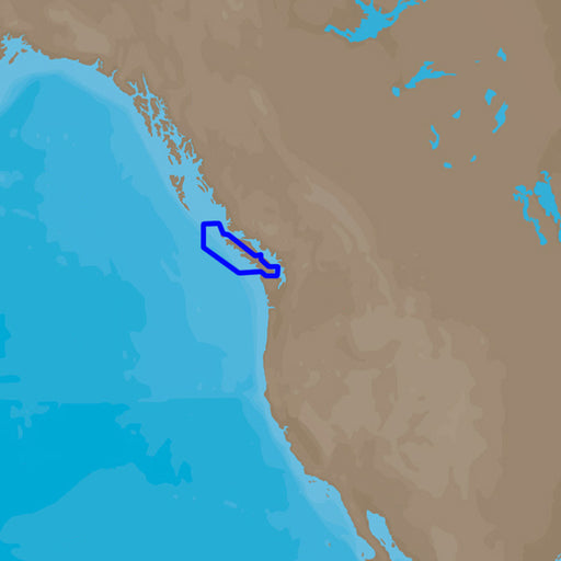
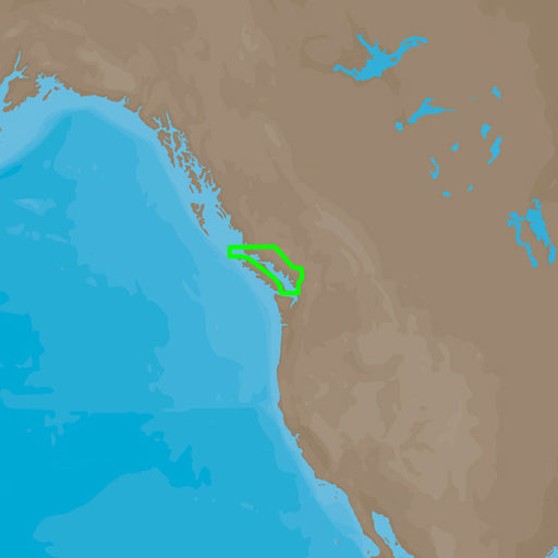
C-MAP 4D NA-D956 Victoria, BC to Cape Scott [M-NA-D956-MS]
C-MAP
Out of stock
C-MAP 4D NA-D956 Victoria, BC to Cape ScottThe next evolution in navigation solutions. C-MAP 4D adapts to your boating needs because it's the onl...
View full details
Original price
$207.00
-
Original price
$207.00
Original price
$207.00
$207.00
-
$207.00
Current price
$207.00
Sold out
Original price
$207.00
-
Original price
$207.00
Original price
$207.00
$207.00
-
$207.00
Current price
$207.00
C-MAP 4D NA-D957 San Juan Islands to Nigei Island [M-NA-D957-MS]
C-MAP
Out of stock
C-MAP 4D NA-D957 San Juan Islands to Nigei IslandThe next evolution in navigation solutions. C-MAP 4D adapts to your boating needs because it's t...
View full details
Original price
$207.00
-
Original price
$207.00
Original price
$207.00
$207.00
-
$207.00
Current price
$207.00
Sold out